Projects/Portfolio
DC Water Potomac Tunnel Basemapping

MAPS (formerly Thoth) was selected to provide High Order Survey control, Aerial Photogrammetry and field run in-fill topography, field edit and Class C Utility location along with Class A Storm and Sewer surveying for a design basemap along the Potomac waterfront. Primary Control had previously been established from recovered NGS monuments and DC Engineer’s Benchmarks. Secondary control was set throughout the project using countersunk brass monuments and were located using two separate sessions of Real-time kinematic GPS and digital leveling techniques to ensure high order vertical values.
Aerial Photogrammetry was collected using a Leica RC30 digital sensor and was localized with photo control points that were established using two separate sessions of RTK GPS. Color orthophotography and CAD feature extraction was created and then field edited and in-filled for any obscured areas. Visible utilities and trees were located during the field survey which provided additional ground truthing of the aerial survey.
Class C utilities were established using the located visible utilities and plans of record provided by the utility stake-holders. Property was established using DC Office of the Chief Technology Officers GIS data, DC Tax and Assessment information, Record and measured survey information of the DC Surveyors office.
Final deliverables included AutoCad Civil 3D 2016 CAD files using the DC Water CAD Standard with embedded digital terrain models, digital color orthophotography.
Area of Aerial Survey Coverage: 860 acres+/-
Area of Field Survey : 177 acres +/-
National Arboretum Boundary Survey, Lot Consolidation and DC Survey to Mark
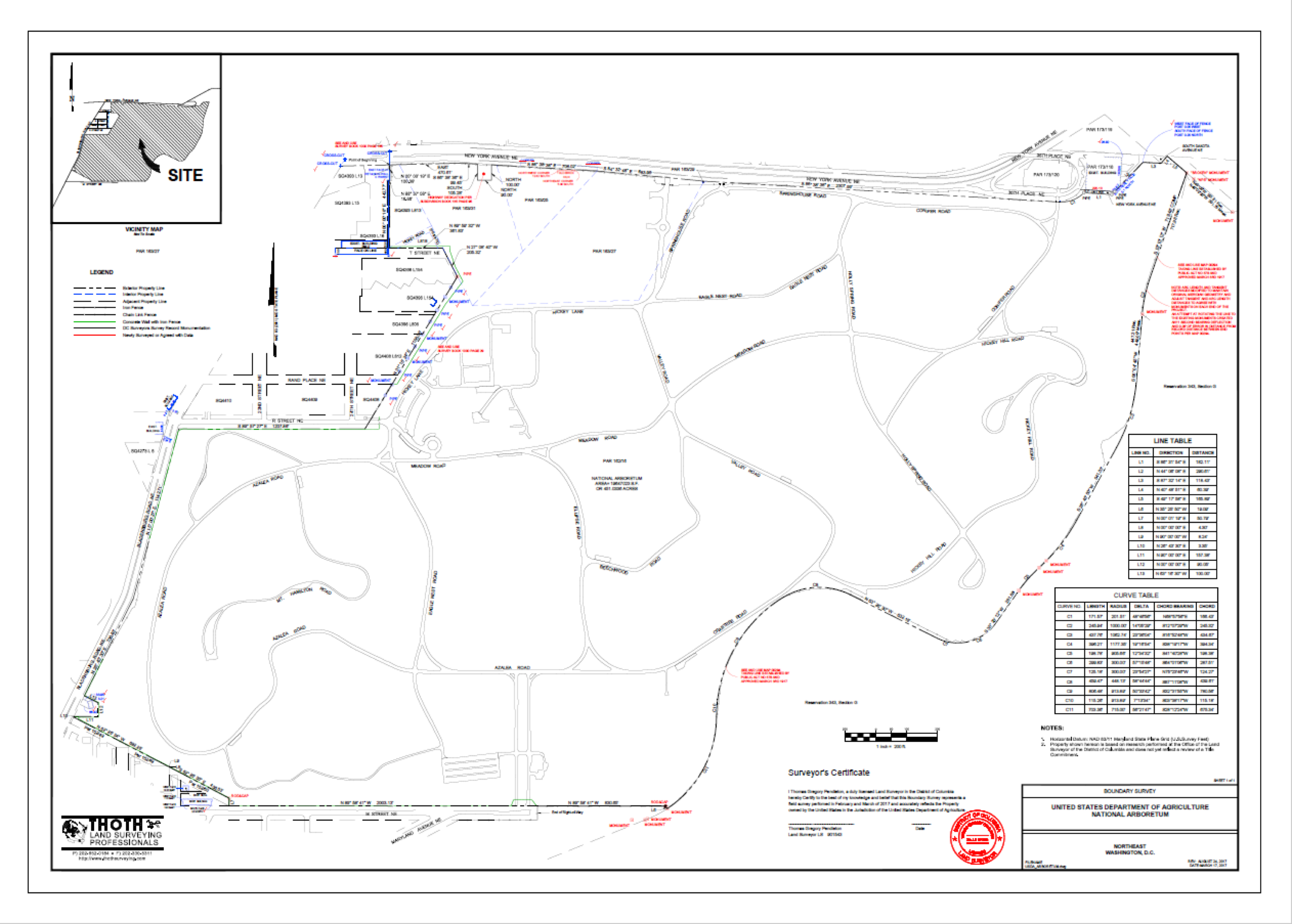
MAPS (Formerly Thoth) was selected by STV Incorporated and the USDA to perform a boundary survey of the National Arboretum located along the Anacostia in the Northeast quadrant of the District of Columbia. Because the Arboretum had been created by the purchase of dozens of disparate parcels of land, Thoth had to create a composite boundary all of the parcels and subcontract a Title search in order that there was ownership of all parcels and no gaps or gores existed in the overall property. Based on Research with the DC Surveyors office and location of monumentation and buildings on the ground; MAPS was able to create a perimeter boundary which could then be monumented, consolidated through Subdivision and put to record with the DC Surveyors office as a Survey to Mark Corners.
Final Deliverables included AutoCAD 2016 and Adobe pdf digital files, Digital title report, digital copies of DC Surveyors office research and hardcopy plats.
Total Area of Survey: 451 Acres.
United States Naval Academy Survey Control Network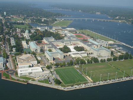
MAPS (formerly Thoth) under subcontract to Woods-Peacock was selected by NAVFAC Washington to recover, densify and updates the survey control monument network for both the Academy and the Naval Support Activies Annapolis.
MAPS began the project by researching legacy control monument data, then using sub-meter GPS techniques and field notes to recover the existing control. MAPS then populated that data into a GIS to indicate such factors as if the monument was still intact, the condition of the monument and if the monument had adequate GPS visibility for review and analysis. Working with stakeholders at NAVFAC Washington and the Academy, MAPS created a strategy to densify the existing monument network taking into consideration factors such as monuments that would not be destroyed based on the Installation 20 year plan, monuments and locations with GPS visibility, creating intervisible pairs for conventional use wherever possible, etc.

MAPS Established 3 Primary control stations using a 36” sand filled pvc with embossed monument boxes finished with concrete and stamped with station information. A stainless steel rod was then driven to refusal (between 16-40 feet in depth) and anchored with a greased sleeve stabilizing fin to prevent frost heave.
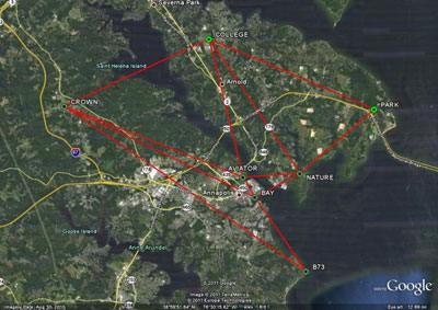
The Primary control monuments were integrated into a GPS control network which employed 4 external National Geodetic Survey NGS passive control monuments and 3 Continuously Operating Reference Stations CORS. GPS Sessions were conducted on 3 different 4 hour occupations, each with different satellite geometry. A Least Squares analysis was performed holding a single known coordinate (minimally constrained) and other published values were compared to the processed results to ensure all coordinates were within the 2cm vertical tolerance. All published results were then held providing a fully constrained network and new values were established on the new primary control monuments.
Primary Control Stations Aviator, Bay and Nature shown among the passive control network:
Once the primary control was established, secondary control points were established using similar monuments and were located during multiple 2 hour GPS sessions with base stations located on the previously surveyed primary control.
Finally, all stations were differentially leveled using a Leica DNA digital level to provide orthometric elevations accurate to within 0.01 of a foot. Two additional NGS vertical control monuments on base were incorporated to increase the confidence in the vertical network.
Final deliverables included an ESRI ArcGIS 9.0 Personal Geodatabase in SDSFIE 4.1, AutoCAD 2007 files showing monuments and control tables, Google KMZ with GIS attribution and Individual datasheets of each control station.
Example (PDF)
Potomac Boat Club Monitoring and Subsidence Survey
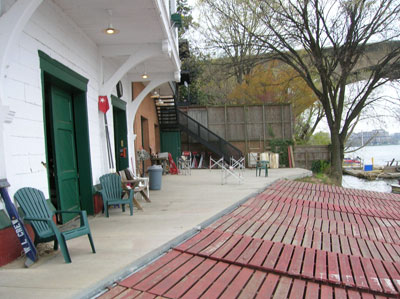
Based on a recommendation from a colleague at the Washington Area Metro and Transit Agency, MAPS was contacted to conduct a subsidence study of the Historic Potomac Boat Club located on the Potomac River in Georgetown, Washington DC. There was a concern that the structure might be settling both vertically and horizontally toward the river. After an initial site meeting, it was determined that permanent survey control monuments would be installed in the river side concrete slab, building floor slab and in the foundation was for annual monitoring.
MAPS set brass survey control monuments in the concrete and building foundation to have a fixed point of reference to repeat measurements during ongoing monitoring.
Horizontal Monitoring was conducted by from 4 36”x3/4” rebar established in pairs on both sides of the Potomac River just west of the Key Bridge. The monuments were surveyed using both dual frequency static GPS and Closed Loop and redundant ties networks with multiple observation conventional angular and distance methods. All observations were processed in StarNet Least Squares software for analysis of precision.
Vertical Monitoring was conducted using Digital Differential Leveling techniques from 2 local National Geodetic Survey Control Monuments. The monuments were both checked between themselves as well as with the GPS to ensure area wide subsidence had not occurred since original NGS values were established.
Subsequent return visits were conducted using similar horizontal and vertical monitoring techniques and delta x, y and z values were evaluated in StarNet using existing provisional coordinates from the initial survey.
Deliverables to the client included a Planimetric Plat and Survey Report (both are attached hereto).
Example (PDF)
Boundary Survey for the Washington D.C. Aqueduct Reservoir in Georgetown
MAPS was selected as a team member with Pride International by the U.S. Army Corps of Engineers to provide a boundary survey on the property surrounding the Washington Aqueduct Reservoir located In Georgetown just north of the Potomac River and C&O canal.
Initial Data Collection consisted of obtaining existing records from the USACE as well as researching with the District of Columbia’s Office of the Surveyor, the National Park Service and the National Archives both in Maryland and downtown DC. Original records were compiled into a plat mosaic in order to do an initial investigation of the subject and adjacent properties to locate all existing property corners and other defined monumentation.
Survey Control was established in NAD83 (2007) Maryland State Plane Coordinate values which the District of Columbia uses as a referenced system using Static GPS and local National Geodetic Survey Continuously Operating Reference Stations. A traverse network around the property was then created using static GPS and Conventional Angle and Distance techniques that were processed in StarNet Least Squares software for analysis of precision.
Property monuments, adjacent structures, fence and roadways were located and a final boundary analysis was determined based on the existing monumentation and deeds and plats of record. MAPS then set concrete monuments with Brass Caps provided by the Army Corp and actually found two additional monuments within 0.2’ of the boundary determination.
Final deliverables included AutoCAD 2007 dwg files, Adobe PDF and signed and sealed hardcopies Example (PDF).